From: https://commons.wikimedia.org/wiki/File:Map_Attached_to_Protocol_Describin... Uploaded by Ndalyrose. (In 1 mosaic) Last modified about 8 years ago. Unrectified.
Links:
|
|
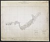
File:Map Attached to Protocol Describing Boundary between the Uganda Protectorate and German East Africa from Mt. Sabinio to Source of R. Chizinga. WOOS-17-2.jpg
From: https://commons.wikimedia.org/wiki/File:Map_Attached_to_Protocol_Describin... Uploaded by Ndalyrose. (In 1 mosaic) Last modified about 8 years ago. Unrectified. Links: |
This map is currently unloaded. You can log in to load it up into the system.
From: https://commons.wikimedia.org/wiki/File:Map_Attached_to_Protocol_Describing_Boundary_between_the_Uganda_Protectorate_and_German_East_Africa_from_Mt._Sabinio_to_Source_of_R._Chizinga._(WOOS-17-2).jpg
A low resolution preview of the map is shown below.

 WMS Capabilities URL
 Tiles base URL
 Download points as CSV
.jpg)