Browse Maps
| Map | Title | Last modified  |
Status |
|---|---|---|---|

|
From: https://commons.wikimedia.org/wiki/File:UBBasel_Map_155u_Kartenslg_AA_124....
Links:
|
about 1 year ago. | Unrectified. |
|
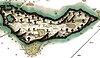
From: https://commons.wikimedia.org/wiki/File:%C3%8Ele-%C3%A0-Vache_Haiti_around...
Links:
|
about 1 year ago. | 3 control points. |
|
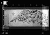
From: https://commons.wikimedia.org/wiki/File:T111-2.jpg (In 1 mosaic)
Links:
|
about 1 year ago. | Unrectified. |

|
From: https://commons.wikimedia.org/wiki/File:Zakroixa_post_map.png
Links:
|
about 1 year ago. | Unrectified. |

|
From: https://commons.wikimedia.org/wiki/File:Fayal_Channel_Cropped_from_Admiral...
Links:
|
about 1 year ago. | 3 control points. |

|
From: https://commons.wikimedia.org/wiki/File:Horta_and_Pim_Bays_cropped_from_Ad...
Links:
|
about 1 year ago. | 4 control points. |
|
From: https://commons.wikimedia.org/wiki/File:Meilenblatt_B_225_Geyer.jpg
Links:
|
about 1 year ago. | Unrectified. |

|
From: https://commons.wikimedia.org/wiki/File:Plan_of_Hounslow_Heath_Baseline_Ro...
Links:
|
about 1 year ago. | 9 control points. |

|
From: https://commons.wikimedia.org/wiki/File:Plan_de_Roye_en_1652,_01.jpg
Links:
|
almost 1 year ago. | 5 control points. |

|
From: https://commons.wikimedia.org/wiki/File:244_of_%27Histoire_de_la_ville_de_...
Links:
|
almost 1 year ago. | 13 control points. |
Displaying Map 4871 - 4880 of 5925 in total. per page.