Browse Maps
| Map | Title | Last modified  |
Status |
|---|---|---|---|
|
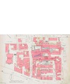
From: https://commons.wikimedia.org/wiki/File:Insurance_Plan_of_Leeds;_sheet_28-...
Links:
|
almost 7 years ago. | 7 control points. |

|
From: https://commons.wikimedia.org/wiki/File:Map_of_West_Toodyay,_1910,_Cons_38...
Links:
|
almost 7 years ago. | 6 control points. |

|
From: https://commons.wikimedia.org/wiki/File:Ceylon_1880.jpg
Links:
|
almost 7 years ago. | 3 control points. |
|
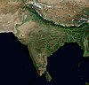
From: https://commons.wikimedia.org/wiki/File:SouthAsia_physical.jpg
Links:
|
almost 7 years ago. | 5 control points. |

|
From: https://commons.wikimedia.org/wiki/File:Karte_Brockenbahn.png
Links:
|
almost 7 years ago. | 3 control points. |
|
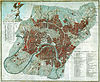
From: https://commons.wikimedia.org/wiki/File:Plan_of_Moscow_1813.jpg
Links:
|
almost 7 years ago. | 7 control points. |

|
From: https://commons.wikimedia.org/wiki/File:JB_map_OSM.png
Links:
|
almost 7 years ago. | Unrectified. |
|
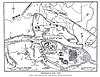
From: https://commons.wikimedia.org/wiki/File:Srirangapatna_map_1792.jpg
Links:
|
almost 7 years ago. | 8 control points. |

|
From: https://commons.wikimedia.org/wiki/File:1839_Monin_Map_of_Ancienne_Italy_A...
Links:
|
almost 7 years ago. | 3 control points. |

|
From: https://commons.wikimedia.org/wiki/File:1718_Carte_de_la_Louisiane_et_du_C...
Links:
|
almost 7 years ago. | 12 control points. |
Displaying Map 5911 - 5920 of 7753 in total. per page.