Browse Maps
| Map | Title | Last modified  |
Status |
|---|---|---|---|

|
From: https://commons.wikimedia.org/wiki/File:Berlin_G%C3%BCter_Bahnhof_der_Nord...
Links:
|
over 2 years ago. | 8 control points. |
|
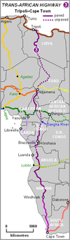
From: https://commons.wikimedia.org/wiki/File:Tripoli-Cape_Town_highway_map.PNG
Links:
|
over 2 years ago. | 5 control points. |
|
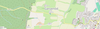
From: https://commons.wikimedia.org/wiki/File:Ganzen%C3%B6d_bei_Isen_auf_OpenStr...
Links:
|
over 2 years ago. | 3 control points. |
|
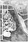
From: https://commons.wikimedia.org/wiki/File:Map_of_Storer_College_campus.jpg
Links:
|
over 2 years ago. | 4 control points. |

|
From: https://commons.wikimedia.org/wiki/File:Karta_MachuPicchu.PNG
Links:
|
over 2 years ago. | 4 control points. |

|
From: https://commons.wikimedia.org/wiki/File:Fifteenth_Street_Financial_Histori...
Links:
|
over 2 years ago. | 6 control points. |

|
From: https://commons.wikimedia.org/wiki/File:1918-1939_circa_Open_GeoData_Plan_...
Links:
|
over 2 years ago. | 6 control points. |

|
From: https://commons.wikimedia.org/wiki/File:1918-1939_circa_Open_GeoData_Plan_...
Links:
|
over 2 years ago. | 12 control points. |

|
From: https://commons.wikimedia.org/wiki/File:1918-1939_circa_Open_GeoData_Plan_...
Links:
|
over 2 years ago. | 15 control points. |

|
From: https://commons.wikimedia.org/wiki/File:1918-1939_circa_Open_GeoData_Plan_...
Links:
|
over 2 years ago. | 4 control points. |
Displaying Map 2891 - 2900 of 7196 in total. per page.