Browse Maps
| Map | Title | Last modified  |
Status |
|---|---|---|---|

|
From: https://commons.wikimedia.org/wiki/File:The_Rand-McNally_New_Commercial_At...
Links:
|
about 2 months ago. | 6 control points. |
|
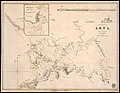
From: https://commons.wikimedia.org/wiki/File:IAN_0558_Cooling_1834_Preveza.jpg
Links:
|
about 2 months ago. | 3 control points. |

|
From: https://commons.wikimedia.org/wiki/File:208-preveza.jpg
Links:
|
about 2 months ago. | 3 control points. |

|
From: https://commons.wikimedia.org/wiki/File:Pittsburgh_Ward_28_election_distri...
Links:
|
about 2 months ago. | 10 control points. |

|
From: https://commons.wikimedia.org/wiki/File:Map_24._Persons_born_in_Poland_in_...
Links:
|
about 2 months ago. | 14 control points. |

|
From: https://commons.wikimedia.org/wiki/File:Plan_d%27intendance_de_la_paroisse...
Links:
|
2 months ago. | 30 control points. |

|
From: https://commons.wikimedia.org/wiki/File:Map_of_the_island_of_Goa_in_India_...
Links:
|
2 months ago. | 17 control points. |

|
From: https://commons.wikimedia.org/wiki/File:Apennin_tosco-%C3%A9milien.png
Links:
|
2 months ago. | 3 control points. |

|
From: https://commons.wikimedia.org/wiki/File:FONSECA1878_p024_MAP_OF_GOA.jpg
Links:
|
2 months ago. | 3 control points. |

|
From: https://commons.wikimedia.org/wiki/File:India_Petermann_1885.png
Links:
|
2 months ago. | 5 control points. |
Displaying Map 131 - 140 of 8838 in total. per page.